
Garganta de los Infiernos

 Located in the heart of the Jerte Valley, the Garganta de los Infiernos Nature Reserve occupies a total of 6,927 hectares of land between the northwest slope of the Sierra de Tormantos, the southwest end of the Sierra de Gredos and the Jerte River itself.
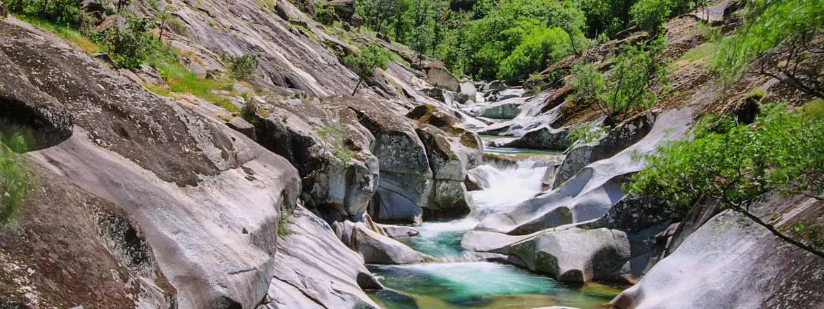
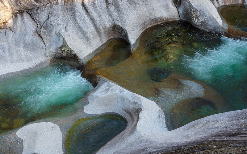
Garganta de los Infiernos is a space of strong natural contrasts. Thus, it is mostly formed by granite and gneiss rocks on which river erosion has drawn a striking landscape of drops, streams, waterfalls and pools.
Among all the terrain of the Garganta de los Infiernos, the area of Los Pilones stands out especially. There are several "marmitas de gigante" or large circular pools that extend along the Serra Gorge, an ancient valley of glacial origin. The Garganta de los Infiernos includes one of the few high mountain ecosystems present in Extremadura.
It extends over the northern slope of the province of Cáceres, where the Cuerda de los Infiernillos and the Cerro del Estecillo stand. At 2,281 and 2,290 metres high respectively, they are the highest points in the protected area.
Vegetation and fauna
The vegetation of the Garganta de los Infernos is divided between areas of deciduous forest (with species such as the melojo oak, hawthorn, strawberry tree, cherry or chestnut). Therefore, these are areas of riverbank where alders, ashes, willows, yews or hollies appear. Finally, there are high mountain areas where the bush and the meadow predominate.
As for the fauna, the mountain goat is the most representative mammal species of the Garganta de los Infernos. Along with it, there are populations of Iberian desman, wild cat or genet. Among the birds of the Garganta de los infiernos, the most important are the birds of prey that are common in the high mountain areas of central Spain. For example, the golden eagle, the peregrine falcon, the kite or the tawny vulture, and other species such as the blackbird, the hoopoe or the black stork.
Hiking and access
There are several signposted routes that allow you to go through the Garganta de los Infiernos on foot. Some of the best known are those of La Umbría, Los Pilones or the Garganta de los Infiernos. In addition, the pool area of Los Pilones is an area of great affluence of bathers from much of Spain during the summer months.
The N-110 road between Plasencia and Ávila is the main entrance to the reserve. On its borders are the towns of Jerte, Cabezuela del Valle and Tornavacas.
Some recommendations to eat and sleep in the surroundings of Garganta de los Infiernos

In Cabezuela del Valle
Rerstaurant El Castillo
Restaurant Tío Pío
In Jerte
Restaurant Napoleón
Bar-Restaurant Valle del Jerte
Restaurant Los Naranjos
Restaurant La Cabaña
In Tornavacas
Restaurant La Covacha
Restaurant Puerto de Tornavacas

In Cabezuela del Valle
Hotel Aljama
Apartamentos El Huerto del Cura
Los Apartamentos Prado del Abuelo
Apartamentos Valle del Jerte
In Jerte
Hotel Los Arenales
Casa Rural El Cerezal de los Sotos
Casa Rural Huracás
Camping Valle del Jerte
In Tornavacas
Casa Rural Finca El Carpintero
Hostal Puerto de Tornavacas
Casa Rural Antigua Posada
Casa Rural El Puente

Calvitero Natura Active Tourism (Cáceres)
Légola Active Tourism (Cáceres)

Visitors' Centre of La Reserva. Ctra. N-110. Km. 369. Phone: +34 927 014 936. GPS coordinates approx. 40º 12′ 21.63″ N – 5º 46′ 23.34″ W.