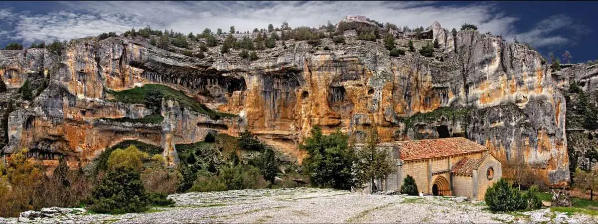
Cañón del Río Lobos Natural Park

 The Cañón del Río Lobos Natural Park takes up 9,580 hectares and it is about 25 kilometers long.
It forms a kind of axis that consists of some lands from the northwest of the Province of Soria and the south west of Burgos.
It is located in a low height mountain range in the middle of the northern third of Spain, delimiting an imaginary border between the Cantabrian Mountains and the highest part of the Duero plain.
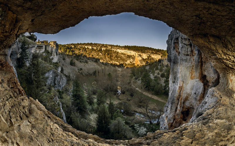
The Cañón del Río Lobos Natural Park is mainly made up of a big limestone canyon that has been formed through the centuries by the effect of the river on the stone. The continual action works in two different ways: erosion and dissolution.
This latter is the one that has changed the landscape more gracefully. It has formed attractive concavities whose colours are due to the minerals that contain the water and the rock in the wall interior flanks. The Natural Park Cañón del Río Lobos is found in a rugged terrain that increases the beauty of the location.
Vegetation and fauna
Related to its flora, its most representative tree is the Juniperus thurifera, but there are also pine groves, Portuguese oak or Valencian oak, holm oaks, black poplars and willows. The volume of the river is in some stretches filled with water lilies and other floating plants.
The fauna of the Cañón del Río Lobos Natural Park is usually not visible during the daylight hours as there is no much space to hide in the narrow canyon. There are roe deers, wildboars, foxes, hares (sometimes you can also see squirrels). We recommend you to take binoculars since in its crags inhabit griffon vultures, eagles, common kestrels and peregrine falcons. It is easy to see them flying or in their nests.
Hiking and how to get there
There are several marked itineraries to walk around the Cañón del Río Lobos Natural Park such as the Sendero Ibérico Soriano, the Ruta del Río (that cover the canyon following the riverbed) or the Ruta de las Gullurías.
Furthermore, the Natural Park has inside or in the outskirts important heritage actives like the castle of Ucero and the chapel of San Bartoolomé (linked to the Templars). In the village of Ucero is the cave of the Galiana Baja.
The south entrance to the Natural Park is located in the road SO-920 between Burgo De Osma and San Leonardo de Yagüe. We do not recommend the northern entrance because of the road signs. You should leave the car in the village of Hontoria del Pinar (Burgos) and go to the south.
A third option is the road SO-934 that crosses the park in the middle of its route, between the villages of Guijosa and San Leonardo de Yagüe.
Recommendations on where to eat and where to sleep around

Province of Burgos
In Hontoria del Pinar
El Chato restaurant
Province of Soria
In El Burgo de Osma
Virrey Palafox restaurant
Puente Real restaurant
Mesón Marcelino restaurant
In San Leonardo de Yagüe
Mesón el Portalón restaurant
Mesón San Blas restaurant
Asador Don Rodrigo restaurant
In Santa María de las Hoyas
Las Hoyas restaurant
Los Girasoles restaurant
In Ucero
La Parrilla de San Bartolo restaurant
El Balcón del Cañón restaurant

Province of Burgos
In Hontoria del Pinar
El Chato hostel
Entrada Río Lobos holiday cottage
La Casa del Médico holiday cottage
In Casarejos
Posada Real de Carreteros holiday cottage
El Carrascal holiday cottage
In El Burgo de Osma
Río Ucero hotel
Virrey hotel
Termal hotel
In San Leonardo de Yagüe
Manrique de Lara hotel
Torres hostel
Villa de San Leonardo holiday cottage
In Santa María de las Hoyas
Las Hoyas holiday cottage
El Arreñal holiday cottage
In Ucero
Posada de los Templarios holiday cottage
Mari Carmen - La Makila holiday cottage
Lobo rural apartments
Cañón del Río Lobos camping
Soriaventura active tourism (Soria)

Casa del Parque Natural. Carretera SO-920 Km. 16. Ucero. Soria. Spain. Phones 975 376 590 / 975 363 564. GPS coordinates. 41º 43′ 0.67″ N – 3º 3′ 3.77″ W.